FORESTHILL TO PEACHSTONE, A WST SECTION
WST refers to Western States Trail
Tuesday, November 18, 2014
DIFFICULTY: Strenuous to Very Strenuous (due to the descents)
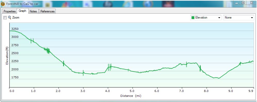
ELEVATION: Lowest elevation — 1776 ft.; Highest elevation — 3252 ft.; Ascent — 1393 ft.; Descent — 2339 ft.
HIKE DISTANCE: 10 miles
GENERAL LOCATION: Foresthill
DESCRIPTION:
This is an exciting opportunity to experience what the WST runners
experience, except that we will hike the trail rather than run!! A bit
of explanation: The WST, or more accurately known as the Western States
Endurance Run, is the world’s oldest and most prestigious 100-mile
trail race. Following the historic Western States Trail, runners climb
more than 18,000 feet and descend nearly 23,000 feet, starting at Squaw
Valley and ending at Placer High School in Auburn. This hike won’t be
quite that challenging, but it won’t be easy either — hence it is
called “strenuous” This WST section will start in the town of
Foresthill, and descend (see attached graph) into, what will seem like,
the deepest darkest recesses of the canyon. Then the trail undulates
for a few miles, crossing several small mountain streams, reaching
another steep descent, and finally a climb out of 1.3 miles. The
feeling of this hike is quite different from most hikes — remote and
wild and majestic! We will stop partway at one of the WST checkpoints,
Dardanelles also known as Cal 1, for lunch. Peachstone or Cal 2 is
another WST checkpoint where we begin our hike out to our cars.
Note:
This will be a shuttle hike — there is only one way in and one way out.
Please RSVP to Scott Thompson via email (scottime@pacbell.net) if you
are planning on attending this hike — and let him know if you are
planning on driving, or would be available if needed. It will be
helpful to know ahead of time how many hikers are coming and how many
drivers will be needed in order to arrange the shuttle.
HIKE CO-LEADERS: Scott Thompson and Sue Geisler
SPECIAL NOTES:
FACILITIES:
There is no bathroom at either end of this trail. We will announce a
bathroom stop prior to leaving LH the day of the hike. It will be
somewhere in Foresthill.
PREPARATION FOR HIKE:
1)
Bring a copy of your ID (driver’s license), health card, and an
emergency contact name and phone number with you when you hike.
2) If you have any health issues, please consider your condition before hiking.
3) Always bring 2 pairs of shoes, along with a plastic bag to store your muddy/dusty boots after the hike.
4)
Bring lunch and water. Trekking poles are highly recommended for the
steep descents and crossing a few streams.
RISKS: Steep
descents. If you have any knee issues, this would not be a good hike
for you. Length of hike — 10 miles — so endurance is very important. If
the trail is wet from rain, the
leaf-covered trail may be slippery. In sections the trail is rocky and that could possibly be slippery.
RAIN CANCELS THE HIKE, and it will be rescheduled at a later time. QUESTIONS: Call Scott Thompson at 543-8215, or Sue Geisler at 408-1010.
MEETING TIME: 7:45 AM LEAVING TIME: 8:00 AM
DRIVING DIRECTIONS
PREHIKE PHOTOS
HIKE PROFILE
|