|
TABLE MOUNTAIN HIKE
THURSDAY, APRIL 6, 2017
DIFFICULTY: Strenuous -- cross-country
hiking with unavoidable muddy/boggy sections pitted by cows, plus areas of
sharp volcanic rock. Several steep descents and ascents on loose rock through
ravines. Eight rocky stream crossings. Hiking poles strongly recommended!
ELEVATION: Starting elevation 1360 feet, total elevation gain 900
feet
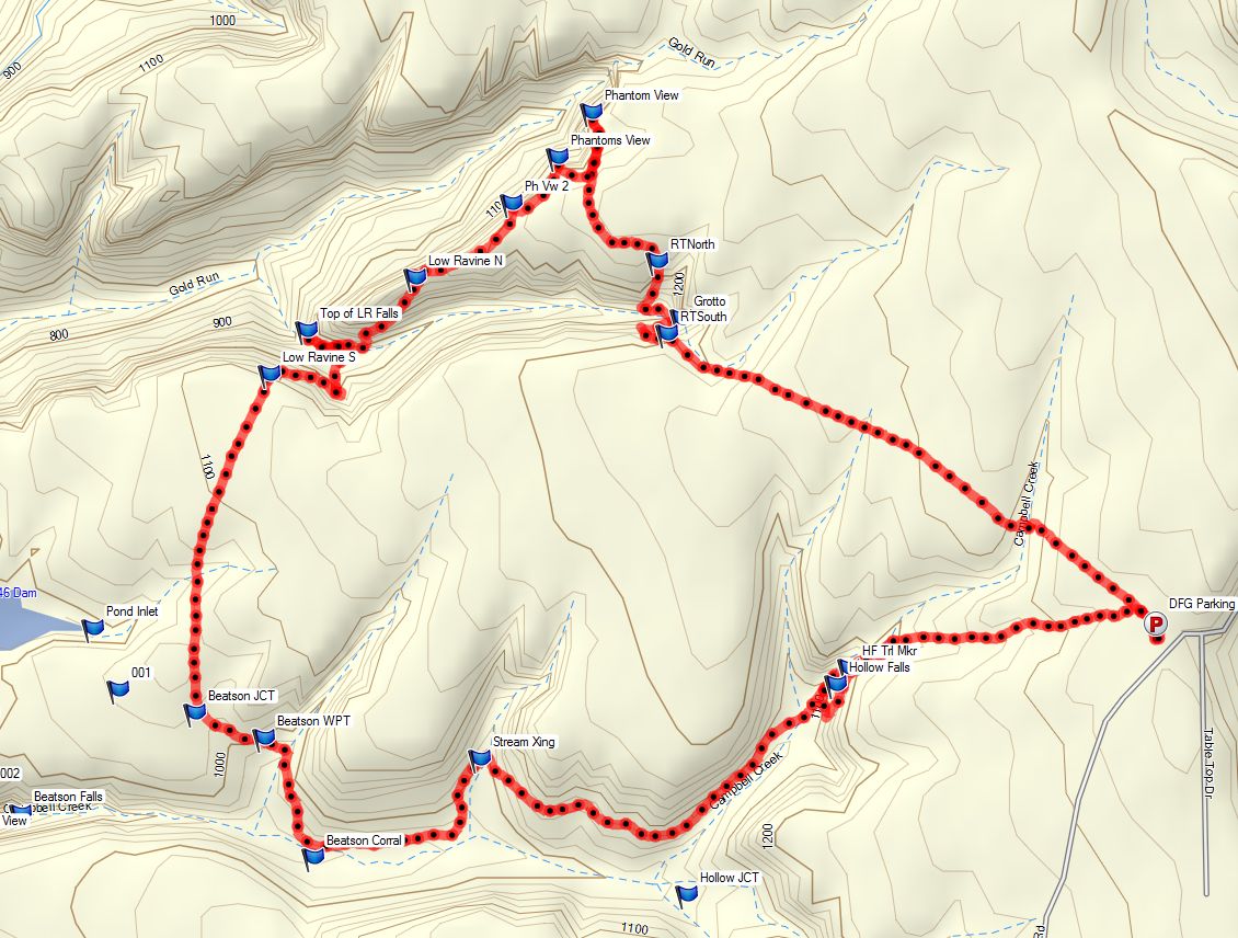
HIKE DISTANCE: 6 1/2 mile loop
GENERAL LOCATION: North of Oroville
DESCRIPTION: As one hiking books states: "the bleakly
beautiful, rolling landscape is reminiscent of the Scottish moors... The
greatest glory of Table Mountain comes in Spring, when the flowers bloom,
transforming the plateau from dark basalt-brown to gold, blue, red, white, and
lavender." The area is one of the premier wildflower areas in
California. Our loop hike will take us to two spectacular waterfalls.
TRAVEL TIME/DISTANCE: About 72 miles one way and 1
hour & 40 minutes driving time. Return time to Lincoln about 4:30
pm. A donation to drivers of $12 is suggested.
HIKE LEADER: Gay Mackintosh SWEEP: Ed Murach
SPECIAL NOTES:
FACILITIES: Portable toilets at the trailhead
PREPARATION FOR HIKE:
1) Bring a copy of your ID (Driver's License),
health card, and an emergency contact name and phone number with you when you
hike.
2) If you have any health issues, please
consider your condition before hiking.
3) Always bring 2 pairs of shoes, along with a
plastic bag to store your dusty/muddy boots after the hike.
4) Bring lunch, water, hiking boots, and
trekking poles (highly recommended for traversing the rocky and uneven
sections plus
8 stream crossings).
RISKS: You
will get muddy! May also get wet on stream crossings. Sharp volcanic rock,
loose in some areas.
RAIN CANCELS HIKE
QUESTIONS: Call Gay Mackintosh at 209-3628
MEETING TIME: 7:45 AM LEAVING TIME: 8:00 AM
DRIVING DIRECTIONS
Photos from the PreHike
Route and map overview
|