|
STEVENS TRAIL
TUESDAY,
APRIL 7, 2015
DIFFICULTY:
Moderate to Strenuous. Moderate because it is an easy down to
the
river, but strenuous because it is all uphill on the return trip and
some sections are steep uphill.
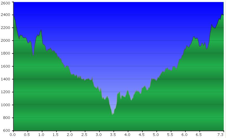
ELEVATION GAIN:
Starting elevation — 2400 ft. Lowest elevation —
1200 ft.
HIKE DISTANCE:
7 miles, An “in and out” hike, not a loop. The BLM (Bureau of
Land Management) sign at the trailhead (9 miles) is not accurate.
GENERAL LOCATION:
Colfax — off Hwy. 80 east of Auburn
DESCRIPTION:
The Stevens Trail is one of the most popular and scenic hikes in the
Sierra foothills due to the magnificent views of the North Fork of the
American River. Spring wildflowers add to the beauty of the
area,
as does a pretty cascading waterfall. While the descent is
gradual, there are some “step-ups and step-downs” that require care in
traversing in both directions — going down and going up. On a
warm day, the continual hike up on the return leg can make the hike
feel “strenuous”. A long section of the trail is cut into the
steep sides of the river canyon and there is a precipitous drop-off on
one side, so this is not a good hike for a person who has vertigo
problems. Most of the trail is single track. We will eat
lunch
sitting on rocks at the river’s edge.
TRAVEL TIME/DISTANCE:
About 3/4 hour driving time and 25 miles one way. Return time
to
Lincoln — approximately 3:30 pm. A donation of $4
is
suggested for riders. Driving directions — see below and
please
print before coming to the hike, if driving.
HIKE LEADER:
Sue Geisler SWEEP: TBD
SPECIAL
NOTES:
FACILITIES: There is a portable bathroom at the
trailhead.
We might also use McDonalds at an exit from Hwy. 80.
PREPARATION FOR HIKE:
1) If you have any health issues, please consider your
condition before hiking.
2) Bring a copy of your ID (driver’s license), health card,
and
an emergency contact name and phone number with you on the hike.
3) Always bring 2 pairs of shoes, along with a plastic bag to
store your muddy/dusty hiking boots after the hike.
4) Bring lunch, plenty of water, hiking boots, and trekking
poles
(strongly advised for crossing the waterfall and for balance on the
narrow trail).
RISKS:
Poison oak is alongside the trail but can be avoided. Ticks
are active this season!
Narrow
trail with sharp drop-off on one side — in one long section.
Some
of the trail is exposed to the sun, and on a hot day the ascent can be
quite a challenge.
RAIN CANCELS THE HIKE.
QUESTIONS:
Call Sue Geisler at 408-1010.
MEETING TIME:
7:30 AM
LEAVING
TIME: 7:45 AM
DRIVING
DIRECTIONS
For photos from a previous hike, click [here]
Hike
Profile
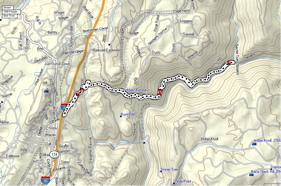
Hike
Route
|