ANNIE’S ROCK
STEBBINS COLD CANYON RESERVE
Tuesday December 17th 2019
DIFFICULTY:
Strenuous if we opt for the in and out route. Strenuous with a
bold and italicized capital “S” if we come back from Annie’s Rock on
the canyon loop trail.
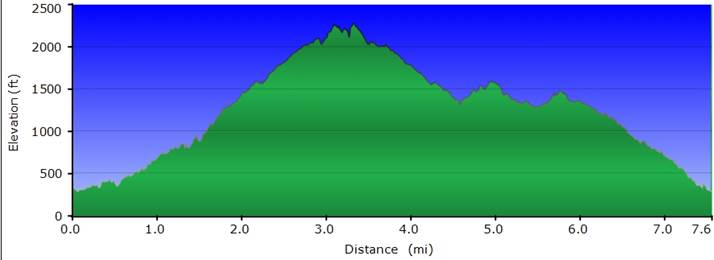
DISTANCE:
Eight miles with approximately 2,500 feet of elevation gain after we do
a few roller coaster hills on the trail. This eight miles
includes Stebbins Loop Trail and Annie’s Trail combined.
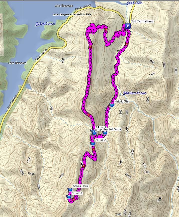
GENERAL LOCATION: Annie’s
Rock Trail is a 2.75 mile detour off the Stebbins Cold Canyon Natural
Reserve Loop Trail located in the Putah Creek State Wildlife Area on
Highway 128 west of Winters.
DESCRIPTION:
Annie’s Rock is a prominent boulder outcropping perched high above Lake
Berryessa along the Upper Cretaceous rocks of the Vaca Mountains (rest
assured, I had to look that one up). Getting to Annie’s Rock is
just plain fun! After departing the parking lot we have a little
rock hopping in a dry creek, go through a culvert tunnel, along a
single path trail, cross the creek, and head for the steps.
Steps? What do you mean steps? Why yes, our “step class”
will include over 200 wooden steps along the trail with the final 183
being just below the Annie’s Trail junction.
Once on
Annie’s Trail we have the options of a 2.75 mile total in and out or
loop route. The in and route is a
straightforward single path. If we opt for the loop we get to do
some root grabbing, boulder hopping along a ridgeline, some mud
stepping, and a couple of short lung busting-calf muscle burning steep
sections. What could be more fun than that?
Returning
from Annie’s Rock can be done as an in and out back DOWN the 200+
wooden steps or finishing the Stebbins Loop Trail which adds one more
mile back to the parking lot (and about 500’ total of roller coaster
hills elevation gains and losses). There is some ridgeline
boulder hopping/crab walking along this route. The last portion
of the loop trail will be a dirt road with some mud.
TRAVEL TIME AND DISTANCE:
68 miles. Suggested driver donation: $12.00. ETA back
to Orchard Creek Lodge approximately 3:30 p.m. without stopping for
lunch.
HIKE LEADER / SWEEP: Mike Nusink / TBD.
FACILITIES AVAILABLE: Handicap accessible porta-potty at the trailhead parking lot.
PREPARATION OF THE HIKE
1)
Bring a copy of your ID (driver’s license), health card, and
emergency contact name and phone number
with you when you hike.
If you have any health issues, please consider your condition before hiking.
3)
Always bring an extra pair of shoes along with a plastic bag to store
your hiking boots after the hike.
4) Bring a snack or lunch and plenty of water.
5) Trekking poles will come in very handy on this hike.
RISKS:
Rock hopping in a dry creek bed, boulder hopping or crab walking on a
ridgeline with steep drop offs, muddy or wet trails, a couple of steep
sections necessitating grabbing a tree root or limb.
QUESTIONS: Please call Mike at 916 644 0508.
MEETING TIME:
7:30 a.m. Orchard Creek parking lot aisle 14. Departing at 7:45
a.m. Returning to SCLH at approximately 3:30 p.m. without
stopping for lunch.
DRIVING DIRECTIONS:
Take your favorite route to I-80 westbound.
Go west on I-80 to Davis.
Turn north on SR 113 and drive past UC Davis.
Exit SR 113 at W. Covell and turn left and go west on W. Covell.
Stay on W. Covell for several miles and bear left when you encounter a fork in the road.
W. Covell will transition into Russell Blvd. Continue S/W on Russell, go up and over Highway 505 and thru Winters.
Russell
Blvd transitions into SR 128 after Winters. Continue west on SR
128 for several miles until you reach Canyon Creek Resort/RV
Park. Drive past the resort and cross Putah Creek on the cement
highway bridge.
After crossing the bridge take the first
right hand turn you encounter which is the parking lot for Stebbins
Cold Creek Reserve.
Compliments of Ed Murach we have:
ROUTE MAP
ELEVATION CHART
PREHIKE PICTURES
|