|
Sand
Ridge Lake/Andesite Peak
Tuesday, July 25, 2017
DIFFICULTY: Strenuous. This hike has a couple of
very steep sections with loose rock, and some nearly steep sections with more
loose rock.
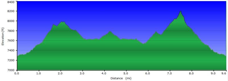
ELEVATION GAIN: 7300’
to 8200’ with 1600 ft. total elevation gain.
HIKE DISTANCE: 9.5 miles
GENERAL LOCATION: I-80 at Pacific Crest Trail
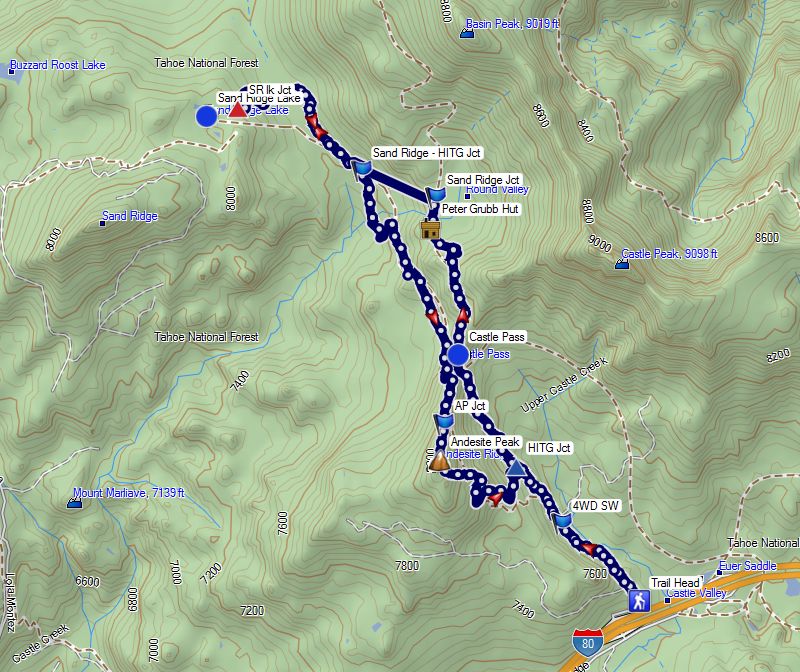
DESCRIPTION: The hike begins at the end of a paved road
accessible from the Castle Peak - Boreal Ridge exit 176, on the North side of
I-80. The hike follows a poorly maintained access road, with some shade,
for about a mile, then connects with the Pacific Crest Trail, then climbs an UPhill
grade to Castle Pass. Views of Castle Peak are available in the breaks in
the tree line. The meadows in the beautiful Round Valley, past the peak
may still have some wildflowers. After passing the Peter Grubb Hut, we
take a shady trail to the left called the Hole In The Ground Trail (HITG Trail). At
a trail junction about ½ mile along that trail, we follow the signs for Sand Ridge
Lake. The last half mile into the lake requires finding a trail sign on
top of some rocks, and is steeper, but it leads to a really nice place for
lunch, swimming and great views of the lake. On the return hike, we will
follow the HITG Trail with a significant grade to Andesite Peak(optional), then
down some gentle switchbacks, with most of the trail downhill and in the
shade. The final half mile of the hike is the access road we started on.
TRAVEL TIME/DISTANCE: One and a half hours each way. One way
distance is about 75 miles. This is a $12 driver donation. Driving directions
will be handed out to all drivers. We should be back about 5:00.
HIKE LEADER/SWEEP: Ed Murach / Barb Proffitt
SPECIAL NOTES: (due to cancellation of Thunder
Mtn, we did not do a pre-hike)
It is possible to cool off in the lake.
FACILITIES AVAILABLE:
None, so we will stop at the Gold Run Rest Stop.
PREPARATION FOR HIKE:
Sturdy boots are required and trekking poles are recommended, but not required.
There are no major stream crossings. Bring lunch and plenty of water.
IF YOU HAVE ANY HEALTH ISSUES, PLEASE CONSIDER YOUR
CONDITION BEFORE PREPARATION FOR HIKING.
BRING THE FOLLOWING: Bring a copy of your ID (driver's
license), health card, and an emergency contact name and phone number with you
on the hike.
ABOUT YOUR FOOTWEAR: Always bring two pairs of shoes, along
with a plastic bag to store your muddy/dusty hiking boots after the hike.
Do not get your driver's car dirty by wearing your dirty boots on the drive
home.
RISKS: High
elevation (7000 ft. +), steep trail sections and a couple of narrow sections
QUESTIONS: Barb Proffitt - 916 -434-6271
MEETING
TIME: 7:15 in the
Orchard Creek Parking lot - leaving time is 7:30
HIKE ROUTE HIKE PROFILE PREHIKE PHOTOS
|