|
Stagecoach Trail Modified
Tuesday December 17,
2013
DIFICULTY: MODERATE and at an
easy pace
ELEVATION GAIN: 700 feet
HIKE DISTANCE: 6 miles
GENERAL LOCATION: Auburn State Recreation Area (ASRA) - near the town of
Auburn. We will park at the ASRA office.
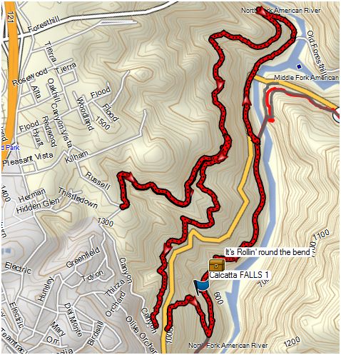
DESCRIPTION: This hike combines a number of trails along the North Fork
of the American River. We start near the ASRA Park Headquarters and descend to
the Western States trail, which we follow to the Mountain Quarries Railroad
Bridge (a.k.a. "No Hands Bridge") at the confluence of the North Fork
and Middle Fork. This trail partially follows the old railroad right-of-way
that led from the old Mountain Quarry on the Middle Fork to the main railhead
in Auburn. We can see evidence of the railroad artifacts, such as old bridge
abutments. From there we precede uphill to the Stagecoach Trail. The Stagecoach
Trail was once the main artery between Auburn and the gold mining settlements
of Yankee Jim and Iowa Hill. From this trail we intersect the Manzanita Trail,
and return to our starting point.
TRAVEL TIME/DISTANCE: Distance
is about 15 miles and 1/2 hour to the trailhead. Return time to Lincoln
about 3:00 pm. A donation of $3 is suggested for riders.
HIKE LEADER/SWEEP: Scott Thompson/Sue Geisler
SPECIAL NOTES: See tick alert on front page
FACILITIES AVAILABLE: Limited access bathroom at ASRA headquarters and
another one about 2.5 miles from the trailhead.
PREPARATION FOR HIKE:
1) IF YOU HAVE ANY HEALTH ISSUES, PLEASE CONSIDER YOUR CONDITION BEFORE HIKING
2) Bring a copy of your ID (driver's license), Health Card, and an emergency
contact name and phone number with you when you hike.
3) Always bring 2 pairs of shoes, along with a plastic bag to store your
muddy/dusty hiking boots after the hike. DO NOT get your driver's car dirty by
wearing your dirty boots on the drive home.
4) Bring lunch and water. We will lunch on the trail. Hiking poles are always
recommended.
QUESTIONS: Call Scott Thompson
at 543-8215
MEETING TIME: 9:00, leave at 9:15
RAIN or MUD CANCELS THE HIKE: BE SURE TO CHECK THE WEBSITE THE MORNING OF
THE HIKE TO DETERMINE STATUS OF THE HIKE.
PREHIKE PHOTOS
GPS TRAIL TRACK
DRIVING DIRECTIONS
|