|
Muir Beach
Shoreline via the
Pacific Coast Trail
(includes
a tour of the Bay Model in Sausalito after the hike)
Thursday,
May 30, 2013
OVERVIEW
OF THE DAY: This is a day trip
with great views of the
blue Pacific, making the long drive well worth while. The day
will start
with a drive to the coast to avoid the triple digit temps of Lincoln.
A 7 mile hike overlooking the
Pacific with spectacular scenery and ocean breezes will highlight the
day. After the hike we will take a short drive to Sausalito
to
view the most interesting Bay Model (see description below). Then we
will relax after our scenic hike while enjoying
a salad,
burger, sandwich, pizza or brewery favorite at the Marin Brewing
Company at
Larkspur Landing. Plan to join us for a fun day of
spectacular hiking,
cooler temps, a unique trip to the Bay Model, and a relaxing meal at a
fun restaurant.
For those
wanting a shorter hike, you have the option to only hike in one
direction only. You’ll be dropped off at the Tennessee Beach parking lot and can
stroll leisurely one mile to Tennessee Beach.
We’ll meet you there after hiking from Muir
Beach
to Tennessee
Beach.
After we’ve all eaten lunch we will all hike back to Muir
Beach
together. This would reduce the hiking distance to
approximately 4.5 miles and give you a relaxing couple hours at Tennessee
Beach.
HIKE
DIFFICULTY: Moderate to
strenuous, depending on your
plan to hike both ways. The elevation gains can be
a bit tedious,
particularly on the initial part of the hike where the grade is a bit
steeper. The return part of the hike will seem easier with
more gradual
switchbacks.
ELEVATION
GAIN: Approximately 1400
feet. You climb
500 feet from Muir
Beach
to the ridge, hike along the ridge, and then
descend 500 feet to Tennessee Beach.
Then you go
back the way you came. With other ups and downs the total
elevation gain
is around 1400 feet.
The
cooler temperatures will make
the elevation gain feel more like 1366 feet.
HIKE
DISTANCE: 7 miles total – out
and back. Or 4.5 miles if you
opt to hike in only
one direction, then to the Tennessee Beach
parking lot.
GENERAL
LOCATION: The trail head is
at Muir Beach on the
Pacific Coast, west of Sausalito.
HIKE
DESCRIPTION:
With the heat
bearing down in Lincoln, take a
refreshing
trip to the coast for a 7 mile hike overlooking the blue waters of the
Pacific. This hike has spectacular scenery. (See
pictures
below.) The trail is the Pacific Coast
trail (not to be
confused with the Pacific Crest trail in the Sierras) and is right on
the coast
overlooking the Pacific where the temperatures will be refreshing and a
breeze
you can count on. Wildflowers will be in bloom.
After about
3.5 miles we will drop down to Tennessee Beach for
our lunch
break. Bring a towel (or something similar) to use on the
beach sand
while eating lunch. And after lunch we will retrace
our steps to
the north and now view the Pacific on our left side. The
ocean view will
likely look even more beautiful when viewed in this direction.
After the hike we will take a short drive to Sausalito and
view the Bay Model.
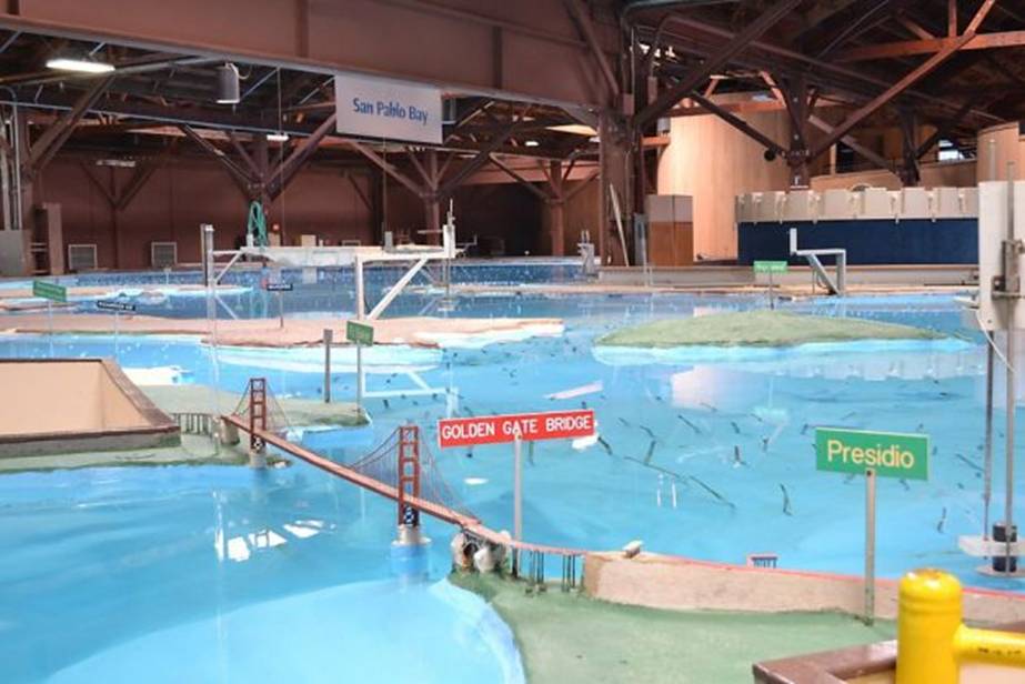
BAY MODEL DESCRIPTION (Quoted from the SF Chronicle)
At first sight, the San Francisco Bay Model is utterly overwhelming.
Standing
on the observation platform, above the acre-and-a-half scale
reconstruction of the Bay Area's waterways, you can scan from the
Sacramento-San Joaquin River Delta across San Pablo Bay to the Pacific
Ocean. As you descend the ramps to walk closer to the edge of the
waterways, you can examine the Port of Oakland and Alameda, or gaze
across the Marin Headlands, the Golden Gate and beyond.
This
fascinating and unique facility is one of the Bay Area's best open
secrets - a remarkable tool that enables visitors to visualize and put
the ecology of the bay's watershed into context. It's a terrific way to
educate kids about the effects humans can have on our natural water
systems. Best of all, it's free.
Built by the Army Corps of
Engineers in 1957 as a way to examine the impact that John Reber's
proposed dam system would have had on the bay, the model demonstrates
in a concrete way the delicately interlinked natural and man-made
systems that bring fresh water from the Sierra Nevada, down rivers and
creeks, to meet the salt water of the Pacific Ocean.
After a
two-year renovation, the Bay Model reopened earlier this year, and
longtime fans will be happy to know that the familiar spots around the
San Francisco Bay are all still there - including the miniature Golden
Gate Bridge straddling the deep channel that leads to the ocean and the
Splash Zone miniature ballpark.
Clever pumping systems enable
hundreds of thousands of gallons of water to ebb and flow in tides that
cycle every 14 minutes - if you watch carefully, you can actually see
the water flowing through the Golden Gate, or creeping through the
Suisun Slough. In 2000, when computer modeling became a more efficient
way to study the impact of changes to the watershed, the Army Corps of
Engineers turned the model into a one-of-a-kind educational tool.
It
will take at least an hour to fully appreciate the entire facility, and
scattered throughout are plenty of hands-on exhibits and video kiosks
that the kids will find interesting.
What effect did dredging
new shipping channels in the San Joaquin River have on the delta? How
did runoff from mining during the Gold Rush change the rivers? How big
is that system of dikes and levees in the delta, and what would happen
if the levees failed? If you or the kids have walked along the Napa
River or driven over the Carquinez Strait, if you've visited Alcatraz
or landed on the runways by the bay at SFO, the Bay Model will put all
your travels around our waterways into perspective.
And when
you walk outside to take in the view across the water from Sausalito,
you'll have a fresh appreciation for the beauty and fragility of the
bay.
9 a.m.-4 p.m. Tuesday-Friday, 10 a.m.-5 p.m. Saturday-Sunday. Free.
2100 Bridgeway, Sausalito. (415) 332-3871.
LUNCH:
Bring your
lunch. A lunch break is
planned for mid hike at Tennessee Beach.
Also a towel
is recommended to use on the sand.
TRAVEL
TIME / DISTANCE
/ PARKING: Travel time is
approximately 2 hours and
15 minutes and 120 miles from Lincoln.
We will stop for dinner prior to returning home to Lincoln.
Suggested
contribution for riders is $18. Detailed driving
directions will
be handed out to all drivers.
HIKE
LEADER / SWEEP: Dennis Ratay /
Margaret Ratay
SPECIAL
NOTES:
FACILITIES
AVAILABLE: A comfort station is
available at the trailhead.
PREPARATIONS FOR HIKE
1)
IF YOU HAVE ANY HEALTH ISSUES, PLEASE CONSIDER YOUR CONDITION BEFORE
HIKING.
2)
Bring a copy of your ID (driver's license), health card, and an
emergency contact name and phone number with you on the hike.
3)
Always bring 2 pairs of shoes, along with a plastic bag to store your
muddy/dusty hiking boots after the hike. DO NOT get your
driver's car dirty by wearing your dirty boots on the drive home.
4) Hiking boots and
poles recommended.
Be prepared for any type of weather - bring layers and sun screen, a
hat and
some water.
RISKS:
Weather
on the coast can be unpredictable, so plan for anything from
fog to sun.
QUESTIONS:
Call Dennis Ratay
at 543-9935.
MEETING
TIME: 6:45
AM -- Leaving
time: 7:00 AM. We will not return
to Lincoln
until 7 or 8 o’clock in the evening.
LINKS
Driving Directions
Map
of Hike Area
Photos from pre-hike
Bay
Model Photo
|