TINKER KNOB via COLDSTREAM VALLEY
TUESDAY,
SEPTEMBER 11, 2012
Difficulty:
Strenuous
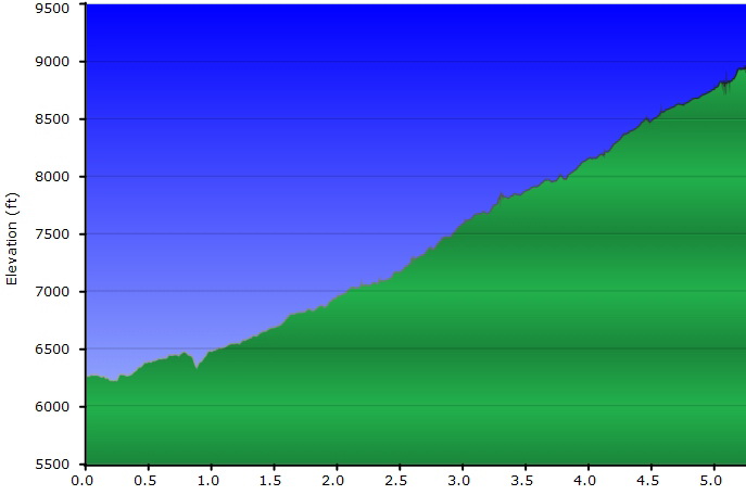
Elevation gain:
2775' going from 6175' to 8950'
Hike distance: 10.5
miles
General location: E
of Donner Lake in Coldstream Valley
Description: 360°
views!!! This is an in and out hike. The hike starts on a dirt road, goes past
Lost Trail Lodge, becomes a trail through forests with a couple of stream
crossings and eventually meets the PCT. Essentially it is 5 miles up to the
base of the Knob where we will have lunch and do the final rock scramble to the
top. The spectacular views include seeing the longer trail that we used to hike
in our younger days. Then we will cruise back down the 5
miles.
Travel
time/distance: About 85 miles. The last 3 miles are a slow dirt road so it is
about a 2 hour drive. This is a $15 driver donation. Hopefully, we'll return
to Lincoln around 6PM, but possibly it will be 7.
Hike leaders:
Chris Wefers and Ed Murach. Sweep: Barb Proffitt
Special notes: We
need drivers with high clearance vehicles. We will stop at the Donner Rest Stop
on the way up. Bring plenty of water for the ascent. It can be windy at Tinker
Knob so have an extra layer of clothing. This will be a good warm-up for the
Tahoe getaway hikes.
Preparation for
hike:
1) IF YOU HAVE ANY HEALTH ISSUES, PLEASE CONSIDER YOUR
CONDITION BEFORE HIKING
2) Bring a copy of your ID (driver's license), Health Card,
and an emergency contact name and phone number with you when you hike.
3) Always bring 2 pairs of shoes, along with a plastic bag
to store your muddy/dusty hiking boots after the hike. DO NOT get your
driver's car dirty by wearing your dirty boots on the drive home. 4) Bring lunch more water than you think you need
Questions: Barb
Proffitt 434-6271
Meeting time: 7
AM - LEAVE: 7:15
Tinker Knob Weather Forecast:
http://forecast.weather.gov/MapClick.php?lat=39.2453&lon=-120.2845&site=sto&unit=0&lg=en&FcstType=text
Driving
directions: Go E on 80 about 68 miles to Exit 184 for Donner Pass Rd. At stop
sign go straight and stay on Cold Stream Rd. After .3 miles there is a 2nd gate
with a sign (No dumping, parking...) - turn L to stay on Cold Stream. In another
.1 veer right and follow signs for Cold Stream Road or Lost Trail Lodge for 3 more
miles. Cross the stream and park before the RR tracks.
Hike Profile
|